The Land
Land Status
The most dramatic change in land ownership and land status in the nation's history is taking place now in Alaska. Not only are lands changing from federal to state ownership as a consequence of the Alaska Statehood Act and into Native ownership pursuant to the Alaska Native Claims Settlement Act (ANCSA), but the lands remaining in federal ownership are undergoing change from public domain holdings to reserves for particular purposes, such as national parks and national wildlife refuges.
A review of the series of changes which have occurred on the state level will provide a framework for regional land status. To aid the understanding of terminology used in this section of the report, definitions of land classification categories are given in Figure 167.
Prestatehood
The United States purchased Alaska from Russia in 1867. The new possession was physically remote from the contiguous United States and was inhabited almost exclusively by Natives. Although the Native population consisted of Eskimos, Indians, and Aleuts, they were categorized as Indians for federal government purposes. Since the Indian country in the United States was administered by the Army, responsibility for governing Alaska was assigned to the Department of the Army.
Military control continued until 1884 when Congress passed the Organic Act for Alaska, giving it a semblance of civilian government by applying the General Laws of the State of Oregon "so far as they may be applicable" to Alaska. The 1884 Act also extended the U.S. mining laws to Alaska, making mining claims legal—Alaska's first land law—and designated Alaska as a land district with an office at Sitka.
In 1898 provision was made for railroad rights-of-way in Alaska. Homestead laws were extended to Alaska in the same year, and the public land survey system followed in 1899. The Civil Code for Alaska, adopted in 1900, added many more facets of government, notably local government and taxes on property. Territorial government was initiated with passage of a second Organic Act in 1912.
In 1923 President Warren G. Harding established by Executive Order the Naval Petroleum Reserve No. 4 following reports of potential petroleum occurrence in the Arctic.
Construction of the Alaska-Canada (Alcan) Highway during World War II, for support of defense installations, made Alaska accessible by land from the contiguous United States. The Highway and the development of commercial air transport furnished a viable link with major population centers and permitted Alaska to achieve the economic and population levels necessary for statehood.
Early interest in Alaska's land centered on mining, but as more visitors came to the Territory and more of its land was explored, opportunities broadened. Conservation sentiments began to develop in the nation around the turn of the century, and the Federal Government began to withdraw and earmark some public domain lands in permanent national ownership, which had a major impact on Alaska. Tongass National Forest, established between 1902 and 1909 and still the nation's largest, was the first such area in Alaska. The Tongass and Chugach National Forests encompass 21 million acres of land along the coasts of southcentral and southeastern Alaska. Later, Mt. McKinley National Park and two national monuments, Glacier Bay and Katmai, were created to protect areas of unusual natural beauty and preserve them for the enjoyment of present and future generations.
Unique scenery is only one quality of Alaska. Many species of fish, birds, and other wildlife inhabit the area and produce and raise their young in particular environments not duplicated elsewhere in the United States. The Federal Government set aside additional lands for this purpose when it recognized the importance of perpetuating significant wildlife populations and their habitats. About 19 million acres are reserved for wildlife preservation on Kodiak Island, the Aleutian Islands, the Kuskokwim and Yukon deltas, the Kenai Moose Range, and the Arctic National Wildlife Range in the far northeast corner of the state. Large areas were also set aside by the Federal Government for military purposes, petroleum reserves, and other public uses. Figure 168 lists major withdrawals of over 1,000,000 acres.
Statehood
The Alaska Statehood Act departed from the traditional methods of providing lands to new states. Congress gave Alaska the right to select the following within 25 years from the date of statehood:
400,000 acres of national forest lands for community purposes;
400,000 acres of public domain for community purposes; and
102,550,000 acres of public domain for general purposes.
With statehood Alaska also became eligible to select within 10 years one million acres under the Mental Health Act of 1956. While still a territory, Alaska had been granted selection of 100,000 acres of land for a university. Therefore, a total of 104,450,000 acres was made available to the State for support of its government and the services it provides to its people. In addition to these land selections, the Submerged Lands Act of 1953 entitles Alaska to tidelands out to the territorial sea and land under the state's navigable lakes and streams.
After gaining statehood in 1959, Alaska proceeded to select its share of the public lands. The 25-year period for completing land selections allows the State an opportunity to inventory and plan for choices that will yield maximum benefit to the citizens of the state. By 1969 less than 10 million acres had been transferred to the State, although considerably more land had been selected by the State and some of it had been tentatively approved for transfer.
During the first decade of statehood, interest in Alaska's lands was not limited to the State Government. Alaskan Natives—the Aleuts, Indians, and Eskimos—claimed title to lands they had historically used, and their claims received official attention. Federal district offices in Alaska referred protests to Washington and issuing of land patents almost ceased. For several years application after application was challenged by Natives, and in 1969 the Department of the Interior withdrew all public lands from state selection, homesteading, or other potential ownership changes.
Alaska Native Claims Settlement Act
The so-called land "freeze" of 1969 continued until December 18, 1971, when Congress passed the Alaska Native Claims Settlement Act (ANCSA), which provides for conveyance of 40 million acres to Alaska Natives according to the formula shown in Figure 169. ANCSA satisfies Native claims to lands and also imposes constraints on the uses and disposition of all remaining federally owned land in the state to insure that planning precedes any actions taken to classify or release the lands.
Figure 169
Total Distribution of Land under the Alaska Native Claims Settlement Act
|
REGION |
Enrollment
Totals2 |
Percent
of Total
Enrollment
(excl. SE) |
Land Surface
Area
(acres) |
Percent
of Total
Area
(excl. SE) |
Acreage
Entitled
to Receive
by Formula
Calculation3 |
Village Eligibility
Based on
Population acres/
(townships) |
Allocation of
Remainder
of 22 million acres |
Net Acreage
Remaining
for Regional
Entitlement
Selection4 |
| |
|
|
|
|
|
|
|
|
|
|
AHTNA |
1,057 |
1.76 |
18,487,988 |
5.3 |
2,001,788 |
714,240 |
(31) |
44,549 |
958,030 |
|
ALEUT |
2,678 |
4.46 |
7,130,339 |
2.1 |
793,162 |
1,152,000 |
(50) |
112,891 |
— |
|
ARCTIC SLOPE |
3,741 |
6.24 |
54,105,162 |
15.6 |
5,892,058 |
829,440 |
(36) |
157,947 |
4,073,511 |
|
BERING STRAITS |
6,965 |
11.61 |
14,810,232 |
4.3 |
1,624,093 |
2,096,640 |
(91) |
293,872 |
— |
|
BRISTOL BAY |
5,135 |
8.56 |
26,021,012 |
7.5 |
2,832,720 |
2,695,680 |
(117) |
216,671 |
— |
|
CALISTA |
13,562 |
22.60 |
35,832,891 |
10.4 |
3,928,038 |
5,460,480 |
(237) |
572,051 |
— |
|
COOK INLET |
8,453 |
14.09 |
24,040,862 |
6.9 |
2,606,102 |
529,920 |
(23) |
356,646 |
1,351,451 |
|
CHUGACH |
1,837 |
3.06 |
9,549,133 |
2.8 |
1,057,549 |
368,640 |
(16) |
77,455 |
465,011 |
|
DOYON |
8,853 |
14.76 |
128,225,207 |
37.1 |
14,012,522 |
3,525,120 |
(153) |
373,605 |
8,142,760 |
|
KONIAG |
3,033 |
5.06 |
4,669,446 |
1.3 |
491,005 |
898,560 |
(39) |
128,079 |
— |
|
N.A.N.A. |
4,681 |
7.80 |
23,102,243 |
6.7 |
2,530,563 |
1,198,080 |
(52) |
197,434 |
778,837 |
|
(totals) |
59,995 |
100.00 |
345,974,515 |
100.0 |
37,796,600 |
19,468,800 |
(845) |
2,531,200 |
15,769,600 |
1 Calculations as of June 8, 1973, Bureau of Land Management.
2 Enrollment count as of May 16, 1973, Bureau of Indian Affairs.
3 Area % x 37,769,600 acres. (SEALASKA will receive 230,400 acres of the total 38 million acres. Calculations are based on remaining acreage.)
4 As some regions contain a large number of villages, the total village eligibility (column 6 and column 7) is greater than the total acreage the region is entitled to receive (column 5). These regions will not receive any regional land (column 8). So that all villages receive their full entitlement, regions which have land in excess of full village entitlement will have their regional entitlement reduced.
Source: AHTNA, Inc. and Arctic Environmental Information and Data Center, University of Alaska, 1973. The AHTNA Region: Background for Regional and Community Planning.
Two subsections of ANCSA contain significant provisions affecting land status. Section 17(d)(1) calls for a review of all unreserved public lands in Alaska "to insure that the public interest in these lands is properly protected." Actually, the (d)(1) classification is comparable to the Multiple Use and Classification Law which expired in 1970 and left Alaska without a federal classification law. The Taylor Grazing Act, which governs land management programs in other public land states, was never extended to Alaska. In March 1974 the Secretary of Interior extended the (d)(1) category to include all unreserved and unappropriated public lands in Alaska. All federal lands in Alaska are in a withdrawal status. Section 17(d)(2) authorizes the Secretary to recommend to Congress the designation of up to 80 million acres of Alaska land for use as national parks, forests, and refuges and for inclusion of some of Alaska's rivers in the Wild and Scenic Rivers Systems.
ANCSA revoked existing Native reserves and will return these unselected lands to the public domain, unless reserve residents elect to take ownership in lieu of ANCSA benefits. The Native Allotment Act was also revoked with a commitment to honor applications which predated ANCSA.
Present and Anticipated Status
Not since the early land grants which encouraged development of the continental United States has there been such a massive redistribution of land ownership. Land transfers have never before occurred in such a short period of time nor affected only one state's political jurisdiction.
When ANCSA was passed in 1971, state land selections, including those tentatively approved, accounted for only about seven percent of Alaska's land area. Land in private ownership was less than one-half of one percent, while federal title still covered more than 90 percent (Figure 170). A decade from now all land transfers under the Statehood Act and ANCSA will be accomplished and the picture will be remarkably different. For example, ownership by Native individuals and organizations is expected to increase the private sector by at least 11 percent (Figure 171). Other increases in private lands have not been estimated, but presumably some state lands will be made available for private acquisition.
Existing federal reserves now equal 25 percent of all land in Alaska, and ANCSA's Section 17(d)(2) designations will increase this amount substantially. The Secretary of Interior, in compliance with ANCSA, made the required withdrawal in March 1972 and subsequently recommended to Congress that 83.47 million acres of Alaska lands be placed in the four traditional systems—National Park, Forest, Wildlife Refuge, and Wild and Scenic Rivers (Figure 172). Change in the reserves would not necessarily be limited to additions. ANCSA, besides withdrawing lands to be studied for inclusion in the reserves, directed the Joint Federal-State Land Use Planning Commission for Alaska to evaluate present reserve lands to determine and recommend their best future uses.
Alaska encompasses over 375 million acres, almost 10 million acres of which is water or ice. Of the land area nearly 97 percent is still owned by the Federal Government. The state contains 11 percent of all national forest land, 31 percent of all national park land, and over 70 percent of all lands reserved for national wildlife ranges and refuges. Figure 173 lists the acreage of these and other federally administered lands as they existed on June 30, 1971, the most recent date for which comparable information is available. The only major alteration in agency acreage is in the Bureau of Indian Affairs. Of more than four million acres administered in 1971, BIA now manages just over 154 thousand acres. Five Native groups elected to take title to reservation land rather than to participate in the Settlement Act. The names and acreages of these reservations follow:
|
Reservation |
Acres |
|
|
|
Tetlin Native Reservation |
768,000 |
|
St. Lawrence Island Reindeer Station |
1,205,000 |
|
Klukwan Native Reservation |
894 |
|
Elim (Norton Bay Native Reservation) |
316,000 |
|
Venetie (Chandalar Native Reservation) |
1,408,000 |
|
Total |
3,697,894 |
Nineteen smaller reservations covering approximately 317,740 acres were abolished by the act, and the lands are now available for Native selection under ANCSA.
Land transfer from federal to state ownership involves by far the greatest change. When the "freeze" order of 1969 was issued, the status of Alaska's land selection program was:
|
Total acres selected |
26,020,394 |
|
Acres tentatively approved |
7,945,893 |
|
Acres patented |
5,828,949 |
After the passage of ANCSA, the State, in January 1972, applied for most of
its remaining entitlement—77 million acres. When boundaries were established
for (d)(2) withdrawal areas in March of that year, many of them were in conflict
with the State's selections. The State subsequently withdrew its application
for 36 million of the overlapping acres, leaving over 37 million acres yet to
be selected to complete the statehood entitlement of 104.45 million acres. Figure
174 shows the record from statehood through 1974 of state applications, tentative
approvals, and patents. The State assumes management of lands when their selection
is tentatively approved.
The Submerged Lands Act of 1953 provides that title also accrues to the State
for lands underlying inland navigable lakes and streams in unreserved public
lands when navigability is determined. Also, tidelands were added to state ownership
out to the territorial sea. This not only increased the amount of land but added
to the total acres within state boundaries.
Tentative approval of state selections is proceeding, as are patents for lands
which are surveyed. As the State receives tentative approvals and patents from
the Federal Government, it classifies lands for retention or disposal. Since
1959 the Division of Lands has classified over 10 million acres of land. All
but 270,000 acres of this remains under the State's resource management program
or is leased for grazing, mineral extraction, or other purposes. Figure 175
shows the October 24, 1975, status of state selections.
Under the Alaska law, boroughs are entitled to select 10 percent of the vacant,
unreserved unappropriated state lands within their boundaries. Figure 176 shows
the status of borough land selections.
Private Lands
Native Allotments—The Alaska Native Allotment Act of May 17,
1906, as amended, authorized the Secretary of Interior to grant up to
160 acres of vacant, unappropriated, and unreserved nominated land to resident
Indians, Aleuts, or Eskimos of Alaska. An applicant had to have been the head
of a family or 21 years of age before the act was terminated. Allotments may
be made in national forests if based on occupancy prior to founding of the forest,
or if the land is found chiefly valuable for agriculture or grazing.
Application was made for about 352 parcels of land (30,000 acres) in southeast
Alaska before the act was negated by ANCSA in 1971. The lands are scattered
throughout the region, mostly orientated to the coast or to streams, and not
necessarily close to large settlements. Many of the applications are for national
forest land which was eligible under the Allotment Act. These applications will
continue to be processed and title granted to qualified applicants. However,
many will not be approved, or if approved, will not include the maximum 160
acres.
Homesites, Headquarters and Manufacturing Sites, Homestead Entries, Small
Tracts, and Mining Claim Occupancy—Very few applications for land
under the settlement laws are active in Southeast, and only a few homesteads
were ever patented in the region. The open lands northeast of Glacier Bay National
Monument are subject to nonmineral settlement application not included in other
claims or withdrawals. There are no open-to-entry lands in the Southeast Region.
Mineral patents are scattered widely throughout the Southeast Region, especially
along the shores of lakes and streams. Oil and gas leases are numerous in the
Yakutat and Gulf of Alaska areas.
Specific information on the status of lands within the Southeast Region may
be obtained from the Bureau of Land Management and the Alaska Division of Lands.
 |
 |
|
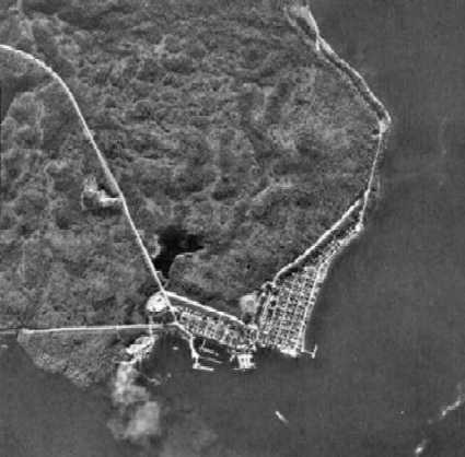
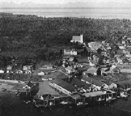
Metlakatla, founded in 1887 as a Tsimshian Indian town, is located on
the west side of Annette Island and is part of the federal Annette Island
Reservation. Its economy is based on commercial fishing and on wood products.
Metlakatla has a new town dock and is connected to the Alaska Marine Highway.
|