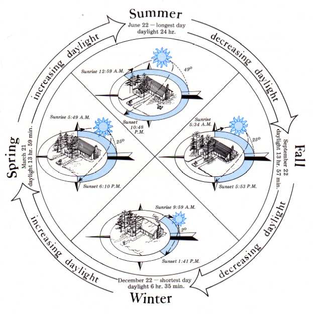
Figure 22. Seasonal Daylight Pattern
Adapted from E.H. Buck, et al., 1976. Kadyak: A Background for Living
Climate
Temperature
Average minimum temperatures in winter and maximum temperatures in summer appear in Figure 10. The range of more than 100 Fahrenheit degrees between summer high and winter low temperatures in the Interior is characteristic of the continental zone, just as a range of only about 40 Fahrenheit degrees is typical of the maritime zone to the south. The National Weather Service, the official weather reporting and recording agency of the federal government reported 100 degrees F (37.8 degrees C) at Fort Yukon on June 27, 1915, as the highest recorded temperature in the state. The lowest recorded temperature was minus 80 degrees F (-62.8 degrees C) at Prospect Creek, about 25 miles southeast of Bettles, on January 23, 1971.
Figure 11 shows the diurnal temperature variationthe difference between the mean annual high and mean annual low temperatures for each daythroughout the state. The diurnal temperature variation in the Interior is nearly double that along the coastlines, but it is considerably less than that in continental locations closer to the equator where more heat is gained during the day and lost at night. During the long periods of sunlight in summer and little or no sunlight in winter, interior locations show little variation in heat lost or gained from day to night. The most important influence on temperature in the Interior year-round is the presence or absence of clouds. Clouds retard heat loss to the atmosphere in winter and reduce heat gain during the summer, thereby moderating both winter and summer temperatures.
|
|
Figure 22. Seasonal Daylight Pattern Adapted from E.H. Buck, et al., 1976. Kadyak: A Background for Living |
 |
|
Yukon Climate
The climate of a particular place is the product of several factors including latitude, altitude, presence of mountain barriers, speed and direction of prevailing wind, and insolation. In interior Alaska latitude superimposes its influence over all others (Wolff and Harding 1967). The climate of the Yukon Region can be generally classified as continental with the exception of a transitional zone in the lower Yukon. However, to be fully understood, climate must be described in terms of local variables and conditions which produce microclimates that may vary within short distances.
The Interior has recorded both the all-time state high temperature of 100 degrees F (37.8 degrees C) at Fort Yukon and the lowest temperature of minus 80 degrees F (-62.8 degrees C) at Prospect Creek. Figure 19 shows climate statistics from 35 stations in the area. Most are located in valleys adjacent to lakes and streams and are not representative of climatic conditions at higher elevations. Data from Arctic Village, with an elevation of 2,020 feet, are included as an indication of the climate at higher altitudes, even though the period of record is only three years.
Summer Fahrenheit temperatures range from the upper 30s to the upper 60s (about 5 to 20 degrees C) with extreme temperatures over 90 degrees F (32.2 degrees C) not uncommon. Winter temperatures range from the minus 20s to plus 20s (about -29 to -7 degrees C) with extreme low temperatures in the minus 60s not uncommon. Coastal temperatures seldom rise above 60 degrees F (15.5 degrees C) in summer or drop below minus five degrees F (-21.5 degrees C) in winter due to the modifying effect of adjacent open waters and marshy areas of the Yukon delta. Frequently, low wind-chill temperatures in the region further reduce the efficiency of men and machinery that work outside during winter. The long summer days, however, allow outside activity 24 hours a day for several months of the year.
Precipitation averages seven to 39 inches annually, and most of that occurs in late summer and early fall as rain and rainshowers. Storms occur year-round but are most frequent in late summer and early fall when the primary storm track penetrates the interior of the state (Figure 5). With few exceptions the highest precipitation occurs in the western part of the region.
The Yukon Region has the greatest area in the state with soils suitable for agriculture (Figure 149). Rainfall amounts are adequate for some crops, but too much rain comes late in the season when crops are maturing instead of during the period of rapid growth. The length of the growing season and number of growing degree days are adequate for some grasses and garden crops.
Shipping on the navigable rivers and streams is only possible about five months of the year when the streams are free of ice (Figure 31). Much of the area is accessible only by air, so aviation is very important to transportation and commerce in the region. Flying weather is generally good year-round since the mountain barriers to the north and south protect the area. Exceptions are the high frequency of ice fog in the winter and the showers and thunderstorms of late summer.
Winds are moderate to strong near the coast but are generally light over the remainder of the area. Several exceptions are Windy Pass near Mt. McKinley and Isabel Pass near Big Delta where the terrain channels wind and increases its speed.
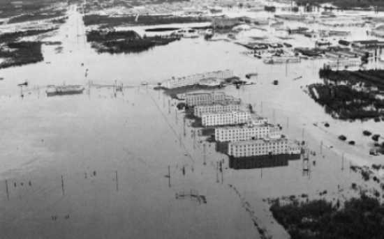 |
| Fort Wainwright after the flood of August 1967 which inundated much of the area bordering the Tanana River. Both the areas around Fairbanks and farther downstream at Nenana were partially covered by the flood waters. Precipitation amounts on August 12 exceeded the monthly average for August at several locations. |
Air Pollution
The central part of the Yukon Region has high winter pollution potential because of the duration of calm winds. Fairbanks, the state's second largest city, has the most severe problem because, in addition to prevalent calm conditions, abundant pollution sources also exist. Instead of terrain acting as a "trap" for pollution such as in Anchorage, persistent inversions in the Fairbanks area concentrate the pollution and prevent dispersal.
The percentage of calm winds varies with the season. For example, the annual calm wind average for Fairbanks is 21 percent; however, February is much higher with 44 percent and May is the lowest with nine percent. Conditions can vary in relatively short distances. Eielson Air Force Base, less than 40 miles from Fairbanks, has an annual percentage calm of 41 and seasonally varies from 55 in January to 21 in June. Percentage of calm on an annual basis can be found in Figure 39. A high pressure system that moves into central Alaska from Siberia often becomes stationary over the Interior, and calm winds can persist for many days.
Temperature inversions compound the problem. Like calm winds, they are most pronounced in winter. When a strong high pressure system settles over interior Alaska in winter, skies clear, and without clouds to stop the outgoing heat radiation, the air at the surface cools and an inversion forms. Since the air in the inversion is very stable, there is no vertical mixing and the pollution concentrates.
Inversion conditions in summer usually occur during the cooler nighttime hours, disappearing during the warmest time of day, so pollution is infrequent. Average summer winds in the Fairbanks area, 75 percent faster than those of winter, combined with the low precipitation totals, about 11 to 15 inches per year, cause high particulate levels in the air in summer and fall. Most of the surface soil is wind-blown loess derived from glacial outwash, so when it dries in summer, it is easily blown around in the atmosphere by wind. After the area has snow cover, measured concentrations are reduced to approximately one-third of summer levels. The Environmental Protection Agency's (EPA) standard for concentrations of particulates has been exceeded an average of eight times a year in the last six years, varying from a low of once a year to as high as sixteen. Smoke from tundra and forest fires is another source of pollution in summer and can substantially reduce both horizontal and vertical visibility.
Inversion statistics for the Yukon Region are only available from Fairbanks and are presented in Figures 41 and 42. Central Alaska inversion conditions are shown in Figure 43, and a comparison with other areas of the state is shown in Figure 45.
The major contributors to pollution in Alaska are automobiles and residential and commercial heating. The only important industrial sources are community power plants. Unfortunately, during winter when the potential for concentrating a pollutant is greatest is when these sources of pollution are producing at peak capacities. The primary problem identified is the concentration of carbon monoxide (CO) in the air. EPA established a CO alert level of 15 parts per million (ppm) and a standard of 9 ppm. In 1974-75 the standard was exceeded 138 times, and alert conditions were reached 39 times. However, newer motor vehicles with anti-pollution devices, improved vehicle traffic patterns, and more favorable weather conditions during the 1975-76 winter reduced the carbon monoxide levels to the point that the standard was exceeded only 70 times and alert conditions reached only 15 times, or almost half those of the previous year.
Population growth in Fairbanks aggravates the problem. Modifying meteorological conditions is extremely unlikely, so the improvements will have to occur by a change in life-style or technological advances. To lower pollutant concentration levels, sources will have to be limited, at least during critical high concentration periods.
Ice Fog
According to Wolff and Haring (1967), ice fog is produced by water vapor discharged during cold weather of minus 25 degrees F (-32 degrees C) or lower. Aside from a few natural sources, most of the vapor comes from automobiles, power plants, and domestic heating. It is usually about 30 feet (9.1 m) thick, seldom more than 100 feet (30.5 m), although thicknesses of 160 feet (50 m) have been observed directly over Fairbanks during long cold spells.
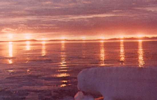
When air containing condensation nuclei cools to varying degrees below the freezing temperature of the liquid water (fog) in the air, tiny ice crystals form. The more polluted the air, the higher the temperature for formation of ice crystals. As the air continues to cool, it can hold less and less moisture. This moisture condenses on already frozen crystals, so that the air and crystals cool slowly. The crystals grow in size, producing beautiful displays of "diamond dust" and "sun dogs." The crystals are well-formed, relatively sparsely distributed, and range in size from 10 to 100 microns. Thus, they present no hazard to visibility and settle rapidly.
Warm exhaust gases discharged into the air may cool 150 Centigrade degrees in a few seconds. Many very small crystals (10 microns) form and create a serious visibility problem. Once ice crystals form, they act as heat sinks from which heat is radiated faster than from air.
Ordinarily, air cools with increased altitude, air moves horizontally and vertically, and the resulting turbulence mixes and clears the air. In cold snow-covered areas, however, radiation from the earth's surface cools the air, causing the gradient to reverse from cold to warm upward, which creates an inversion limiting mixing in the lower atmosphere. The inversion and the ice fog become thicker and more intense as extreme cold continues. In short, conditions for serious pollution problems in the Fairbanks area in winter could hardly be worse, and as population grows, so does the problem.
Figure 44 shows three areas covering 24, 38, and 64 square miles, respectively. The inner area is covered whenever ice fog is present, the next when ice fog continues several days, and the largest area only during prolonged spells of very cold weather. The fog is not continuous, especially near the outer boundaries.
Sea Ice
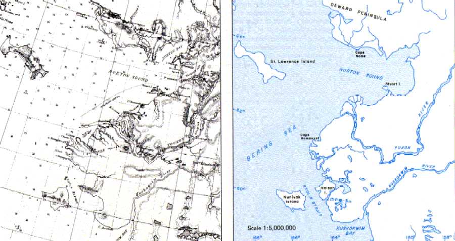
Sea ice is common in the northern Bering Sea, occasionally covering the entire area from late autumn through early spring (Figure 53). Wind-induced ice movement causes ice ridge and hummock formationconvergence of ice flowsmuch as it does on the Arctic Ocean, although ridges probably do not attain as great a height because of the thinner, one-year ice. A discontinuous ice cover is present as a changing mass of irregular fields, floes, and cakes intersected by numerous breaks and leads. One-year winter ice in the Bering Sea generally averages only two to four feet thick. Ice formation in the northern Bering Sea usually begins during November when the permanent polar ice pack reverses direction and starts to move southward from the northern Chukchi Sea. Movement generally proceeds toward Siberia, evidenced by impingement of ice against the USSR coast, while the area adjacent to Alaska or the central Bering Sea and Bering Strait has a well-developed shore lead. Shore ice begins to freeze in early December and increases in thickness until late April. It is found as far south as Nunivak Island.
The ice edge reaches its maximum southward position during late March, both because of temperature and persistent northerly winds which tend to drive the pack ice south. In addition, a southwesterly or westerly drift in the southern Bering Sea between November and April causes a seaward flow of ice from the more shallow area where it forms near the Alaskan coast (Potocsky 1975). In April the ice begins to break up and melt, and the ice edge retreats northward. The general southern limit of sea ice in the Bering Sea is from northern Bristol Bay to the vicinity of St. George Island in the Pribilof Islands. In extreme years, ice may extend as far south as Unimak Island. South of this boundary there is little or no heavy ice, but north of it the Bering Sea has a 50 percent cover over much of its surface for five months of the year.
Ice in the Bering Sea starts to break up in June at the west coast of Alaska. By the end of June the Yukon delta and Norton Sound areas are essentially ice-free and the Bering Strait is almost entirely open. The middle Bering Sea is usually the last part to become ice-free, but ice sometimes stays in the bays and around islands longer than in the open sea (Anderson 1963). The movement and position of the ice depends greatly on wind conditions. River ice breaks up and forms earlier than sea ice; consequently, ice jams and flooding occur in the river deltas and lower reaches during spring.
By the beginning of June the whole body of ice is near St. Lawrence Island, and a passage opens in the western Bering Sea. The eastern side is generally obstructed later than the western side. By late June or early July, the Bering Sea is essentially free of ice. Ice concentration in areas north of Bering Strait continues to decrease as summer progresses. The ice retreats further into the northern Chukchi Sea, eventually merging into one continuous edge that reaches a maximum northward position during the latter half of September. Winter ice in the southern Bering Sea ranges from 12 to 28 inches (30 to 71 cm), while in the northern Bering Sea it ranges from 28 to 48 inches (71 to 122 cm).
Freezeup and breakup conditions are important to man in this environment since they affect marine activities. Figure 54 illustrates mean freezeup and breakup information for selected locations.
Figure 66: Yukon River Delta Maps1860 and Today
 |
|
|
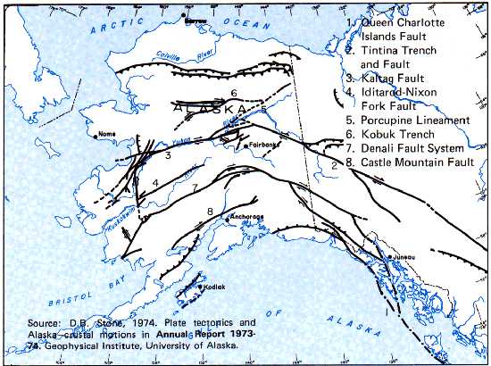
Figure 88. Major Faults of Alaska