Lesson I: The Land and Waters
Outline for Lesson I
General Objectives and Activities Related to Lesson I
Introduction to Lesson I
General Description
Land Features
Maraq (Lowlands)
Nunapik (Highlands)
Mountains
Vegetation
Edible Plants
Medicinal Plants
Uses of Grass
Lakes
Saltwater Lakes
Freshwater Lakes
Rivers and Sloughs
Traditional Man-Made Rivers
Bering Sea
General Objectives of Lesson I
Students will learn to locate Chevak, the Yukon and Kuskokwim deltas, and the state of Alaska on maps.
Students will learn to identify and describe:
Land features
Edible and other useful plants around Chevak
Lakes and the kinds of fish that spawn in saltwater and freshwater lakes
Habitats of waterfowl
Rivers (including traditional man-made rivers) around Chevak
The Bering Sea and its relationship to the people of Chevak
Health and Safety Issues:
Safety rules and conditions to keep dry
Safety rules for boating
Right conduct and disciplinary action for wrong behavior
General first aid instruction
How to operate campstoves and flammable liquids
Safety rules regarding firearms, other tools like axes
Appropriate clothing to bring
Proper waste disposal and personal hygience while camping
Importance of being drug and alcohol free
Activities Related to Lesson I
Draw a map around Chevak and identify Cup’ik place names for rivers and lakes.
Discuss how to avoid getting hypothermia, how to walk without sweating.
Discuss appropriate gear, and clothing to bring for Sea-Week.
Discuss firearm safety while hunting for seal and birds.
Interpret weather conditions as taught by Elders.
Discuss disciplinary action to be taken when one becomes a danger to others by fighting, bothering others, not heeding advice from Elders.
Discuss how to prepare for emergency situations and first aid help.
Discuss proper techniques for use of campstoves, other flammable liquids, and how to use tools such as axes.
Discuss proper boating safety and importance of life jackets.
Discuss importance of cleanliness and keeping environment free of litter.
Camp out as an organized environmental study in remote places as a Sea-Week
activity.
Go on field trips to gather plant specimens from river and lakes.
Identify different types of fish caught in the rivers or lakes.
Make manaqs and fish traps to catch fish.
Go on a field trip and locate where edible plants.
Go on a field trip to locate where poisonous plants grow.
Go on a field trip to gather plants and identify them with Cup’ik and scientific names.
Go on a field trip to manaq and fish in rivers and identify and dissect fish that are eaten.
Go on a field trip to gather seashells and beach objects.
Study and identify the historical and cemetery sites of this region and how they are related to the history of the people.
Gather information for this region from Elders and existing documents.
Go on a field trip to gather medicinal plants from the tundra.
Lesson I: The Land and Waters
Introduction
This lesson describes the major geographical features of our region and explains how the land and its resources sustain the Cup’ik people. It is crucial for users of this curriculum to understand the importance of the land to its inhabitants. For those not familiar with our country, this lesson explains why the Cup’ik people have chosen to live on Alaska’s western tundra.
General Description
The village of Chevak and the surrounding lands are in western Alaska, between the Yukon and Kuskokwim river deltas. It is 20 air miles from the Bering Sea and 130 air miles west of Bethel, the hub of the Yukon-Kuskokwim Delta. About 750 people, mostly Cup’ik, live in Chevak. Chevak is in the Yukon Delta National Wildlife Refuge, which Congress set aside mainly to protect the waterfowl that nest in the region every year.
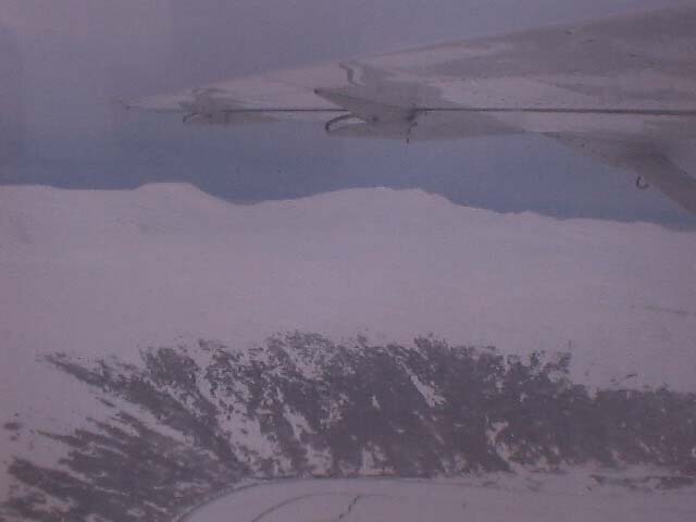
The land around Chevak is vast tundra and looks flat to people traveling by boat or snowmachine. From the air, travelers can see thousands of lakes. During winter, the tundra is still, like a sleeping giant, and in spring it comes to life with millions of nesting birds that migrate here from other parts of the country. When the sun comes up in the morning, the land is cast with many emerging colors. At twilight, colors illuminate the rolling hills and the clouds high in the atmosphere.
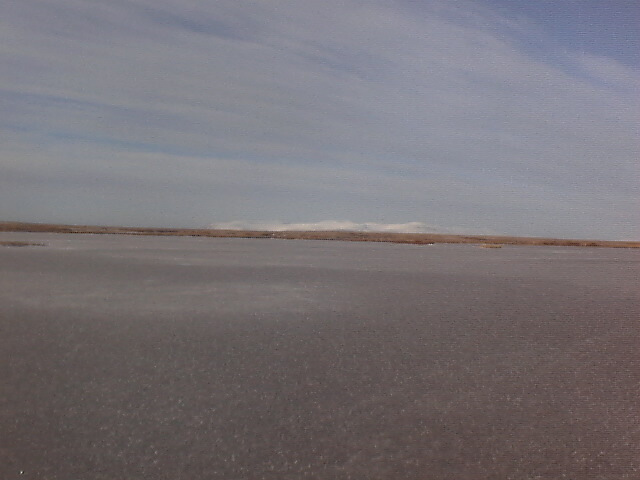
During winter, from October to March, ice and snow cover the country, allowing people to travel by snowmachine. All the lakes, rivers, and parts of the Bering Sea freeze during this time. Between March and May spring arrives. With the snow and ice melting, the tundra comes to life once again. There are rapid water run-offs from the low tundra lands. When the weather becomes extremely warm, the snow melts rapidly and forms deep pools of water on the tundra. These pools then will run off to the sloughs and rivers. The water flows into the ice cracks on the still-frozen rivers. Travelers must be wary of these dangerous conditions, which create large holes on the ice of the lakes and rivers.
Land Features
Although the land in the vicinity of Chevak is flat, further away (between 5 and 60 miles away) are mountains. There are two types of land features in the delta: lowlands, or maraq in Cup’ik; and highlands, which the Cup’ik people call nunapik.
Both the high and lowland areas provide abundant habitat for the many species of migrating birds that nest and raise their young in these areas. For example, white-fronted geese can be found in the highland area, while cackling geese and black brant are often present in the lowland area. Swans also feed in the lowland lakes. Cranes are common in both low and highlands.
Maraq (Lowlands)
Maraq, or lowlands, have the following characteristics: 1) grassy, marshy wetlands; 2) saltwater lakes; 3) coastal flooding; and 4) waterfowl and small species of birds nesting and raising their young in spring and summer.
Nunapik (Highlands)
Nunapik is found in the interior terrain. This is where rivers become fresh water, and salt water is not usually present. Several characteristics identify nunapik: 1) freshwater lakes; 2) abundant berries; 3) no coastal flooding; and 4) driftwood that washes to the edges of nunapik as a result of coastal flooding.
Another important feature of nunapik is sod, which the Cup’ik people use for making sod houses. Sod (which is formed of the tangled roots of tundra plants and grasses) is very strong and is capable of keeping the rain out, if each piece of sod is overlapped on the outside of the house. (Sod house construction is described in Lesson III.) Sod also has many other uses. For instance, it can be used for building emergency shelters on the tundra. Blocks of sod are put in a circle and piled as high as possible; then a roof is made out of driftwood and covered with sliced sod. Also, traditional smokehouses are made of sod and driftwood.
Mountains
Besides the highland and the lowland areas, the other landforms in the region are mountains, which are generally less than 2,000 feet high. Anything bigger then 2,000 would be a massive mountain for us. Most of the mountains have highland vegetation and are often outlined with alder trees and willows; some are rocky.
The Askinuk Mountains are to the north of Chevak. About 30 miles northeast of Chevak, and between Chevak and the Yukon River, are the Kusilvak (or Manelgnok) Mountains. To the east of Chevak are Ingrissaaraq Mountain, Nasqulek Mountain, Ingricukvak Mountain, and Ingrillrat Mountain. Southeast of Chevak, the Nelson Island Mountains appear miniature, with a blue outline. Our ancestors called these mountains Qaluyaat, and they are probably the richest of the mountains around Chevak. The Qaluyaat Mountains provide our people with colored clay. Long ago the Cup’ik people began using this clay to color the masks they carved, and we continue to use it today. The clay is colored red, blue, and white.
 Click
on picture to enlarge
Click
on picture to enlarge
Vegetation
The tundra is treeless, but it has many other kinds of vegetation. In the spring, flowers of many colors display the beauty of the tundra. The lowland (maraq) vegetation consists of mostly of grassy, marshy, and wet lands. This lowland is covered during fall floods caused by high winds and high tides. Berry plants are common in nunapik (highlands), and labrador tea plants are also abundant. Other vegetation in nunapik includes wood-stemmed plants, moss, and lichens.
The Cup’ik people use plants for food, for medicine, for baskets and mats, for insulation, and for much more. Below is a general description of the kinds of vegetation on the western tundra and the plants we use most. It isn’t intended as a comprehensive description. A good source of information on the plant life in this area is Wild Edible and Poisonous Plants of Alaska, published by the Cooperative Extension Service at the University of Alaska.
Edible Plants
The many kinds of berries that grow in the region are important edible plants. Our people pick mainly salmon berries (also called cloudberries), black berries (also called crowberries), bog cranberries, and red berries (lowbush cranberries) for winter use as akutaq, or Eskimo ice cream. Other edible plants consist of pallas-buttercups, sourdocks, and other greens found along the banks of the rivers and sloughs. The only poisonous plant in our region is the water hemlock, which can be found on the banks of freshwater lakes. (Water hemlock is also known as poison water hemlock or muskrat food; children in the Yukon-Kuskowim Delta have died after eating the roots of this plant.)
Medicinal Plants
The Cup’ik people are expert in using some of the plants in the region for medicinal purposes; they can use plants the way doctors do medicine. For example, tea made from the leaves of caiggluk, or wormwood, is used for to fight sore throats, stomach discomforts, and other ailments; poultices are also made from boiled leaves. Caqlak, or rosewort, is used to help heal sores.
Uses of Grass
Grasses in the region have many uses. One plant that has monetary value is the type of blade grass found along the beaches of the Bering Sea. The women of our region pick this grass during fall and make exotic baskets with it. Our region is well known for these beautiful baskets, which are marketed all over the world.
Another grass—a tall, coarse grass—that grows abundantly along marshy land surrounding freshwater lakes in highland areas is called kelugaq. Muskrats eat the roots of this plant. It is a strong grass that Cup’ik people pick when it is green and then dry it until it becomes pale and dead. The women then braid it into beautiful mats for qayaqs.
The tall grass found in the highland land areas is used for insulating sod houses, as well as for boot insoles and bedding for camping outdoors. It can also be used in emergencies. Placing it between the skin and wet clothing prevents severe frostbite.
Another grass, the blade-grass that grows along the lakes, is the diet of geese and goslings. Mice also eat grass roots. During fall freezeup, mice gather two kinds of grass roots on the lowlands and store them in small burrows. The tall grass root is called utngungssaaq and the small grass root is called marallaq. The people of this region, in turn, gather these grass roots to add to soup. In the highlands, mice gather a root called iitaq.
Lakes
By air, travelers can see thousands of lakes dotting the landscape of this region. In the lowland areas the saltwater lakes dominate, while in highland areas freshwater lakes are abundant. The large lakes (both saltwater and freshwater) where various species of fish spawn are called qagatet.
Saltwater Lakes
Microscopic bugs live in these saltwater lakes, so it is important to boil this lake water before drinking it. Clear saltwater can also be used for cooking. Species of fish that spawn in saltwater lakes include cukilek (needlefish), naptaq (whitefish), naternaq( flounders), and kayurrlugaq (bullfish or devilfish).
Freshwater Lakes
The freshwater from these lakes is excellent for making tea or for cooking. During the fall, swans and ducks feed in certain freshwater lakes and rivers. Flocks of swans can easily be seen by their contrasting white color. In the evenings, the trumpet sounds of the swans reveal which lakes and freshwater rivers are being invaded. Big flocks of swans feed from one lake to another, searching for tayaruqs—tiny hair-like plants. Swans and ducks feed off the roots of these plants, which must be highly nutritious—because large flocks of birds concentrate in lakes and rivers with tayaruqs. The birds become fat before migrating to southern countries.
The fish that spawn in freshwater lakes include naptaq (small whitefish), citegtaq (tomcods), can’giiq (blackfish), manignaq (lushfish), cukvak (pikefish), and cukilek (needlefish or stickleback).
Some fish spawn in both freshwater and saltwater lakes; these include whitefish, tomcods, flounders, and devilfish.
Tidal Rivers and Sloughs
Tidal rivers and sloughs run out to the Bering Sea. Most of these rivers and sloughs are silty and muddy. The rivers and sloughs near the seacoast have muddy bottoms, unlike the freshwater rivers of the interior, which have weeds growing in them. Rivers and sloughs around Chevak are interconnected through tributaries that branch out and then come together.
Traditional Man-made Rivers
For many centuries, the Cup’ik people have made rivers and sloughs as shortcuts (cevellret) for boat travel. We make shortcuts by digging a small line between tributaries and thereby connecting two rivers at places where large bends occur. Then the river currents take over, moving water back and forth until small sloughs develop. Over time, the rushing water removes the silt and mud at the bottom until the sloughs develop into rivers. The high concentration of rushing waters during spring thaw helps develop these man-made sloughs into deep channels.
The people of Chevak are well known for making such new rivers to shorten the distance for boat travel. For example, if traversing a bend would take fifteen to thirty minutes, shortcuts can reduce that time to a few seconds. Chevak people have made about five such shortcuts to this day.
In fact, the old Chevak and the present Chevak were named for cev’aq, meaning "the one that has broken through." This refers to rivers that have become connected by the erosion of riverbanks, or lakes that have disappeared and broken through to the ocean. The rivers in this region are constantly changing, and because of this natural process many of the rivers we once knew are gone.
Some of the traditional sites of the Cup’ik people are now underwater or in the middle of rivers, because of riverbanks constantly eroding to one side. This process has also eliminated some of the spawning lakes along the Bering Sea coast; the Cup’ik expression for that is "being blown away to the ocean" or qagerluteng. Many Cup’ik Elders remember being in these lakes with their qayaq at in the 1950s and 1960s.
The Bering Sea
The Bering Sea is the most respected resource of the Cup’ik people. When we go out subsistence hunting in the Bering Sea, our Elders advise us to never challenge the ocean, but to respect it. The beauty of the ocean is reflected when it is calm—and that is one reason why the Cup’ik people will return to the ocean again and again, even though they have encountered hard situations or conditions in the past.
In the Bering Sea, the ice develops during the cold winter months, creating both the lead ice from the shore and the loose pack ice that moves back and forth during low and high tides. When the weather is extremely cold, thin ice can develop, covering all the open water. The seal hunters look for open water in the mouths of large rivers. The ice pack opens during low tide.
It is during the spring season that we concentrate on hunting seals in the Bering Sea. Seal hunting is favorable during March, April, and May, when the weather is usually nice and calm. That contrasts with weather during the fall, when it is typically frigid cold and windy. If hunters know the weather is favorable and the winds are moderate, they will go out to sea, but if gusty winds come up they will head for the safety of shore.
It is important for hunters to learn the river system as one large geographic area—that is, they need to learn all the rivers, their tributaries, and the links between them. In some cases boat routes from one river to the other include tundra lakes. When hunters learn to recognize all the regional landmarks, they have a better chance of surviving. If the weather turns bad, or other situations arise that make it impossible to return home by one route, knowledgeable hunters can find another route. For example, changing ice conditions might mean hunters have to move to a different area to reach shore ice. Some hunters have survived because they were able to find their way to different areas when necessary.
The Cup’ik people use the seal for both clothing and food. The most critical part of the seal is its blubber, which we render and use in our daily diet. We cut the blubber into long strips, then cut the strips almost through crosswise. Then we put these strips in a container and store them in a cool place. The oil slowly renders out of the fat. The resulting oil is very high in vitamins A and D, and we use it in many ways. It adds flavor to soups and stews. We dip dried fish and meat, raw frozen fish, and vegetables in it. It is sometimes used in akutaq (Eskimo ice cream) as well.
Chevak people and those living in coastal villages along the Bering Sea both learn the same hunting and survival methods. There are rules our Elders teach us so we can survive the dangers of the Bering Sea. One of the most important pieces of advice is never to panic when encountering dangerous conditions on the ocean. Lesson III of this curriculum lists all the rules we are taught and describes traditional and current seal hunting methods.
 Click on pictures to enlarge