Purpose
Since Alaska's statehood in 1959, many federal, state, and local government agencies have conducted independent studies related to various natural resource and environmental aspects of Alaska. Planners, citizens, and lawmakers have attempted to use this information for planning and development of land uses or location of capital improvements. However, the extremely specialized methods used by writers or researchers in presenting data and the interpretations of technical data by agencies for specific use, has resulted in limited evaluation of broad and complex problems. Commonly, only a few resource, developmental, or environmental factors pertinent to a particular problem or area have been considered by the public or policy makers. Analysis of specific problems has most frequently failed to give adequate consideration to internal components and external effects, and area planning has seldom been related to the overall needs of the region, state, or nation.
On December 18, 1971, with the enactment of the Alaska Native Claims Settlement Act (P.L. 92-203), Alaska entered a new phase of land use planning. The Act, supplemented by state legislation, created the Joint Federal-State Land Use Planning Commission for Alaska. The Commission is charged with the broad mandate to make recommendations on the use and management of state lands, to advise the Secretary of the Interior and the Congress as to the use and management of federal lands, and to assist the Native corporations established by the Act in their land selection process. To accomplish the Commission's task of preparing the information upon which sound recommendations and decisions could be made, the Resource Planning Team, composed of 34 professionals in various fields of natural resources, was assembled from state and federal agencies.
The efforts of the Joint Federal-State Land Use Planning Commission have been of vital interest to the Office of the Governor, which considers it imperative that the vast amount of information compiled by the Resource Planning Team on Alaskan resources and environment be used as a basis for land use policy planning and public information. The concern of the Governor's office led to cooperative arrangements between the State, the Commission, and the University of Alaska in the preparation of this volume, one of six regional profiles, describing the natural and man-made systems of the State. Resource information, compiled by the Commission's Resource Planning Team, and data on the man-made environment, prepared by the State Division of Planning and Research, are presented here. The Arctic Environmental Information and Data Center of the University of Alaska has provided additional scientific knowledge where necessary and compiled and coordinated the preparation of this volume and series.
The intent of these documents is to provide a factual basis for federal, state, and local governmental planning decisions directed towards the wise use, development, and protection of Alaska's resources and environment. Another purpose of these documents is to provide the foundation for State implementation of a land use planning process responsive to the nation's growing concern for relating natural factors to land tenure and use.
Maps, tables, and explanatory text in these volumes offer scientific and technological data for use by planners, policy makers, and the general public. This information is a summary of current knowledge. Greater detail on specific resources, geographic areas, or scientific topics is referenced in the bibliographies. An effort has been made to present topical text and graphics in a consistent format throughout the Regional Profile Series in order to permit statewide evaluation and correlation of information.
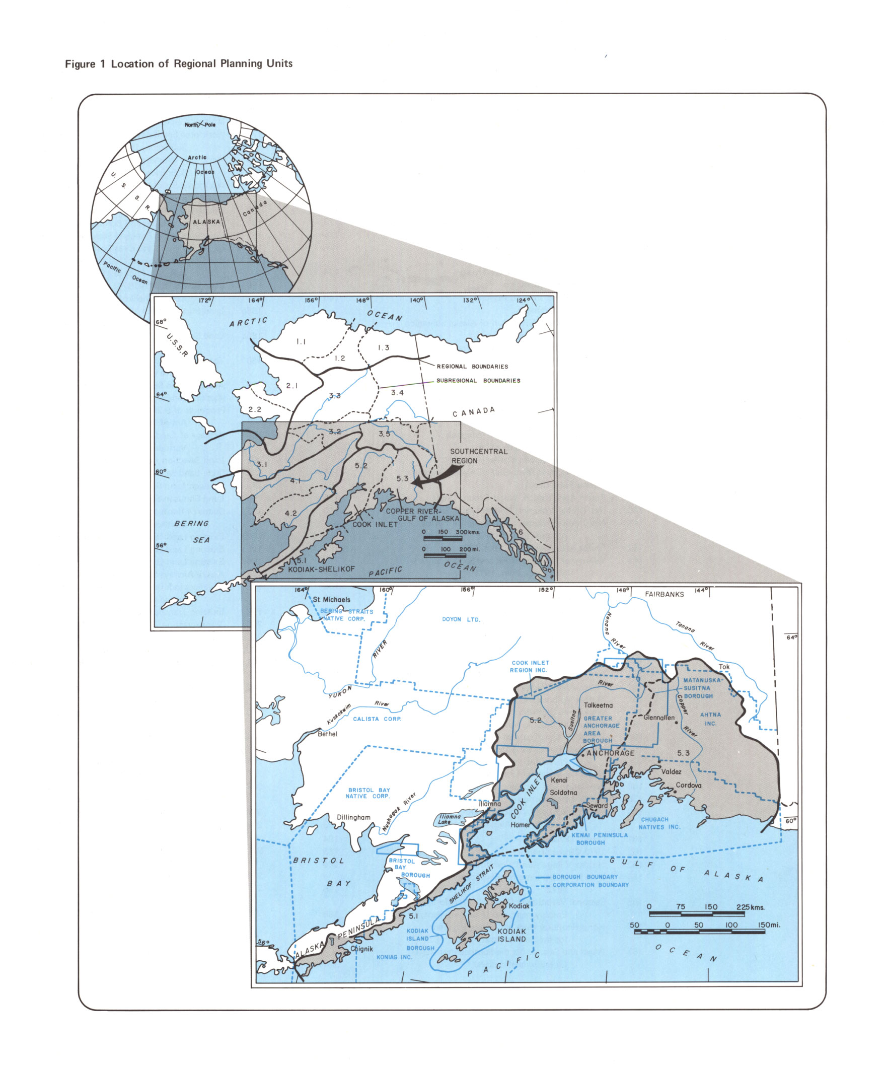
Description of Planning Units
The State of Alaska includes a land area of 586,000 square miles or approximately 375,000,000 acres. Because of the size of the state and the diversity of the land, six major planning regions have been delineated for study, and all but one have been further divided into subregions .
|
*click photo to load a large version, may take longer on 56k modems and less. Use the "Back" button on your browser to return to this screen. |
Both the regions and subregions follow hydrologic boundaries. In other words,
both the regions and subregions include the watersheds of streams within their
boundaries with no regard to the township and range grid system or political
subdivisions. The area of each planning region is shown in Figure 2.
This first volume, Southcentral Alaska, covers 83,000 square miles. Its boundaries contain four boroughs—Kenai Peninsula, Matanuska-Susitna, Greater Anchorage Area, and Kodiak Island; and four Native regional corporations established in compliance with the Alaska Native Claims Settlement Act—Ahtna, Inc., Chugach Natives, Inc., Cook Inlet Region, Inc., and Koniag, Inc.
|
Figure 2 |
|||||
|
|
|
|
|
|
|
|
Region |
Area or Subregion |
Alaska |
Drainage Area Canada sq. mi. |
Total |
|
|
Arctic |
|
|
|
|
|
|
|
1.1 West Arctic |
31,000 |
– |
31,000 |
|
|
|
1.2 Colville |
24,000 |
– |
24,000 |
|
|
|
1.3 East Arctic |
26,000 |
– |
26,000 |
|
|
|
TOTAL FOR THE REGION |
81,000 |
|
81,000 |
|
|
Northwest |
|
|
|
|
|
|
|
2.1 Kotzebue Sound |
41,000 |
– |
41,000 |
|
|
|
2.2 Norton Sound |
26,000 |
– |
26,000 |
|
|
|
TOTAL FOR THE REGION |
67,000 |
|
67,000 |
|
|
Yukon |
|
|
|
|
|
|
|
3.1 Lower Yukon |
38,000 |
– |
38,000 |
|
|
|
3.2 Central Yukon |
19,000 |
– |
19,000 |
|
|
|
3.3 Koyukuk |
33,000 |
– |
33,000 |
|
|
|
3.4 Upper Yukon-North |
60,000 |
25,000 |
85,000 |
|
|
|
3.5 Tanana |
45,000 |
500 |
45,500 |
|
|
|
3.6 Upper Yukon-Canada |
9,000 |
105,000 |
114,000 |
|
|
|
TOTAL FOR THE REGION |
204,000 |
130,500 |
334,500 |
|
|
Southwest |
|
|
|
|
|
|
|
4.1 Kuskokwim Bay |
58,000 |
– |
58,000 |
|
|
|
4.2 Bristol Bay |
40,000 |
– |
40,000 |
|
|
|
4.3 Aleutian |
11,000 |
– |
11,000 |
|
|
|
TOTAL FOR THE REGION |
109,000 |
|
109,000 |
|
|
Southcentral |
|
|
|
|
|
|
|
5.1 Kodiak-Shelikof |
11,000 |
– |
11,000 |
|
|
|
5.2 Cook Inlet |
38,000 |
– |
38,000 |
|
|
|
5.3 Copper River-Gulf of Alaska |
34,000 |
1,000 |
35,000 |
|
|
|
TOTAL FOR THE REGION |
83,000 |
1,000 |
84,000 |
|
|
Southeast1 |
|
|
|
|
|
|
|
TOTAL FOR THE REGION |
42,000 |
35,000 |
77,000 |
|
|
|
|
|
|
|
|
|
|
TOTALS |
586,000 |
166,500 |
752,500 |
|
|
1 Area covered by this report. |
|
||||
|
Subregional numbers 1.1 through 5.3 designate areas of study used by the Joint |
|||||
|
|
The Southcentral study region includes areas draining to the Gulf of Alaska between 141 degrees west longitude and Stepovak Bay on the Alaska Peninsula. The area, approximately 53.1 million acres in size, is characterized by rugged, mountainous terrain with important exceptions in the lowlands bordering Cook Inlet, the lower Susitna Valley, the Copper River plateau, and intermittent strips of lowland along the coast. It includes part of the Wrangell Mountains, all of the Talkeetna Mountains, the eastern and southern slope of the Alaska Range and the Kodiak Archipelago. The region is one of great tectonic activity. Frequent violent movements of the earth's crust give rise to severe earthquakes. Major volcanoes, including Katmai, Augustine, Iliamna, Redoubt, and the Wrangells, also reflect this tectonic activity.
Extensive glacier systems characterize the Alaska, Wrangell, Chugach, and Kenai mountain ranges and the higher mountain areas near Mt. Veniaminof, Mt. Katmai, and Mt. Douglas. Glaciers provide source water for most of the large rivers in the region.
This region has two of the largest river systems in the state—the Susitna and Copper. Their drainage basins account for more than half the total area of the region. Next in size is the Matanuska River with a drainage area of 2,190 square miles. Three other basins—Knik, Chakachatna, and Kenai—exceed 1,000 square miles in area.
The plains of the Copper River plateau, Susitna lowlands, and Kenai Peninsula feature notable concentrations of lakes. Lakes Tustumena, Skilak, George, Chakachamna, Beluga, Louise, Tazlina, Klutina, Black, and Chignik each exceed an area of 10 square miles.
The coastline of the Southcentral Region extends from Icy Bay, northwest of Yakutat, to Stepovak Bay on the Alaska Peninsula. Between these two points lies some 25 to 30 percent (or roughly 11,500 miles) of Alaska's tidal shoreline. This coastline is the most complex in the state. It includes the piedmont glacier beach of the Bering Glacier, the island and fjord complex of Prince William Sound, the wide, shallow Cook Inlet basin, mainland fjords of the Kenai and Alaska Peninsulas, and the fjords of the Kodiak Island group. The coastline is dominated by two mountain systems: the St. Elias-Chugach-Kenai Ranges, which terminate at Kodiak, and the interior-coastal Alaska-Aleutian Ranges, the latter forming the Aleutian Islands. Cook Inlet and Prince William Sound are large coastal embayments containing many small coves and harbors. The continental shelf along the Gulf of Alaska is generally narrow and heavily sedimented on the east, becoming wide with steep rocky walls and deep canyons on the west.
The Southcentral Region is the most populated area in Alaska with about 54 percent (163,800) of the state's population. Anchorage is the largest commercial and distribution center of the region and the state. The terminus of the trans-Alaska pipeline at Valdez, the possible terminus of a proposed natural gas pipeline in the area, and increased fishing activities and tourism indicate continued economic growth and increasing population for the Southcentral Region.
The study region has been divided into three subregions:
(1) The Kodiak-Shelikof subregion (Figure 40a) includes the south and east slopes of the Alaska Peninsula from Cape Douglas to Stepovak Bay, the Kodiak, Trinity, Barren, and Semidi Island groups, and numerous small outlying islands—an area of 11,000 square miles. Most of the area is hilly to mountainous with deeply indented coastlines. Maximum elevations range from 7,000 ft. (2,130 m.) on the mainland, 3,366 ft. (1,025 m.) on Kodiak, to a little more than 1,000 ft. (300 m.) on smaller islands.
(2) The Cook Inlet subregion (Figure 40b) extends from Kamishak Bay on the southwest to Mount McKinley National Park on the northwest and eastward to the Copper River valley, an area of about 38,000 square miles. The towering Alaska Range forms the western and northern boundaries of the subregion which includes the western part of the Copper River basin and the areas drained by the Matanuska and Susitna Rivers. The Talkeetna, Chugach, and Kenai Mountains bound the subregion on the northeastern, eastern, and southern borders, which includes drainages of the Matanuska, Knik, and Kenai Rivers and the Knik Arm.
(3) The Copper River-Gulf of Alaska subregion (Figure 40c), an area of about 34,000 square miles, is bounded on the north by the Alaska Range, on the east by the St. Elias and Wrangell Mountains, on the south by the Gulf of Alaska, and on the west by the Talkeetna, Chugach, and Kenai Mountains. These mountainous areas support the largest ice fields, piedmont glaciers, and valley glaciers in North America. The interior of the subregion is an intermontane plateau drained by the Copper River and its tributaries. The Gulf of Alaska coastal section is formed by the southern flank of the Kenai-Chugach Mountains.
Statewide Climate
Climate means the long-term manifestations of weather as represented by statistics collected during a specific interval of time. The term climate is derived from the Greek word klima, meaning inclination, which refers to the climatic influences of the sun (American Meteorological Society 1959). Climates are definable because the influence of the sun, oceans, and contours of land are sufficiently regular and permanent to bring weather back to normal after temporary departures.
The sun is the source of all heat energy. The amount of energy that reaches and remains on the earth's surface depends on the angle of the sun's rays as they strike the surface and the nature of the material that receives the energy. The equator is nearly perpendicular to the sun's rays and receives the most energy. Alaska is located at a high latitude, and the sun angle is comparatively low, especially in winter. As a result, little or, in some areas, no energy is received during winter months. Instead, there is a net loss of energy or heat to the atmosphere. Warm winds circulate over the state, counteracting the deficit and moderating temperatures. In summer when the earth's northern latitudes tilt toward the sun, the atmosphere over Alaska receives the greatest amount of energy. However, much of this energy is absorbed or reflected back into space because of extensive cloud cover and never reaches the surface.
Water surrounds Alaska on three sides and exerts a strong influence on climate. In winter the ocean is a source of heat and moisture, warming the air and providing water for clouds and precipitation. Winter cloudiness, in contrast to summer, slows down the loss of heat from the surface to the atmosphere by reradiating much of it back to the surface. In summer the moisture source is also the oceans; however, since the air is generally warmer than the water, clouds become the insulating layer, moderating temperatures to some extent in all parts of Alaska, and to a considerable extent in coastal areas.
Land contours is the third factor mentioned in the general definition of climate. Alaska's terrain interacts with both the sun's energy and the ocean's influence on climate. Terrain is a major controlling factor in establishing local climatic conditions. For example, a mountain slope with southern exposure will offer a surface more nearly perpendicular to the sun's rays in winter. More radiant energy will be absorbed, freezing temperatures will occur later in the fall, and warming will come earlier in the spring. Mountains are barriers to general wind patterns; this may cause lower wind speeds on the leeward side and heavier precipitation on the windward side where clouds accumulate. Increased cloudiness affects both the incoming and outgoing solar radiation. All these factors are related through interaction.
Alaska contains four major climatic zones (Searby 1968); Maritime, Continental, Transition, and Arctic (Figure 3). Weather conditions vary within each zone, but certain conditions predominate.
In the Maritime Zone water is the major influence. This zone includes Southeast Alaska, a narrow band along the north coast of the Gulf of Alaska and the south side of the Alaska Peninsula, the Aleutian Islands, and all of the islands in the Gulf and along the Pacific side of the Peninsula. Compared to other areas in Alaska the weather in this zone exhibits heavy precipitation, cool summers, and warm winters. Surface winds are persistently strong in most areas.
South of the central Brooks Range and inland from the coastal Maritime Zone lies the Continental Zone of Interior Alaska. Generally, both summer and winter temperatures are extreme and precipitation is light. Except for a few isolated locations, surface winds are light.
Generally, the Transition Zone consists of a band of varying width between the Maritime and Continental Zones. Weather is variable; it may be Continental, Maritime, or a combination. On the average, temperatures are more extreme than in the Maritime, but less than in the Continental Zone. Precipitation amounts also fluctuate between the two. Surface winds are generally light with numerous exceptions.
The Arctic Zone extends from the central ridgeline of the Brooks Range north to the ocean. No Maritime or Transition Zones have been designated along the Arctic Coast, primarily because of the nearly continuous frozen condition of the Arctic Ocean. However, minor marine influences moderate temperatures along the coast. Precipitation levels do not increase in the coastal area because of proximity to the Arctic Ocean. Surface winds are strong along the coast, but decrease further inland.
Southcentral Climate
The climate of Southcentral Alaska falls into three of the four climatic zones. Obviously, all coastal area and islands fall into the Maritime Zone. With no terrain influences involved, annual precipitation amounts to about 60 inches, including snow. In some areas the same air pushed up mountainsides may produce more than 200 inches of moisture. Temperatures usually reach the upper 50s for mean maximums during summer and drop into the low 20s for mean lows during winter. Temperature extremes often appear out of place with the mean. These extremes result from outbreaks of extremely cold air in winter and relatively hot air in summer from the interior of Alaska. The strongest surface winds in this region, both in averages and extremes, occur in the coastal area. Offshore speeds average between 12 and 18 knots; slightly less on shore because of surface friction. Extremes of 50 to 75 knots are common in winter, and can exceed 100 knots when channeled.
The interior climate of the region is in the Continental Zone. Mean maximum temperatures in summer are mostly in the mid- to upper-60s and mean lows in winter range from 10 to nearly 30 degrees below zero F. Annual precipitation is generally between 10 and 15 inches. Where terrain is a factor, annual totals may exceed 20 inches. Heavier amounts usually occur at elevations above those now inhabited by people. Surface winds are light compared to those of the coast. Channeling through mountain valleys results in narrow bands of strong winds in some local areas.
In the Transition Zone weather conditions average between the Continental and Maritime Zones. Temperature extremes most resemble those of the Continental Zone, while precipitation amounts tend to range from light (near 10 inches) to heavy enough to maintain glaciers. Surface winds range between coastal and interior conditions, including channeled winds.
Sea Ice
Sea ice in the Southcentral Region is found primarily in Cook Inlet, north of the Forelands (Figure 36 ). Occasionally, small icebergs break off coastal glaciers and are found along the rim of the Gulf. Water temperatures of about 40 degrees F limit their existence. Shore fast ice is found in bays and inlets, particularly where streams flow into them.
In general, upper Cook Inlet ice moves slowly south where water temperatures are higher. As a result, large ice concentrations south of the Forelands are rare, occurring only when air Temperatures are extremely low for prolonged periods. The ice is thicker and more extensive than usual under these conditions.
Temperature controls ice growth in upper Cook Inlet (Hutcheon 1972). Research directly related to Cook Inlet ice growth is very recent. Ice research done in other locations, principally the Russian and Canadian Arctic, forms the basis for forecast procedures now used routinely on Cook Inlet ice. Figure 37 shows the relationship between ice thickness, freezing degree days, and snow cover of the ice. Even one inch of snow forms an effective insulation layer. For example, with no snow, 470 freezing degree days are required for an ice thickness of 30 inches. With one inch of snow, 880 degree days, or almost twice as many are required. Figure 37 also shows the difference in requirements between forming and melting sea ice. Almost twice as many degree days are needed to form ice as to melt it.
The amount of snow cover is an important factor in the growth of ice. Decreases in thickness require fewer thawing degree days than were necessary to form the same thickness.
Tidal Action
If there were no tidal action in Cook Inlet, a solid sheet of ice would form at freezeup in the fall and remain until breakup in the spring. Tidal action and tidal currents keep the Inlet ice in shattered condition. The tidal range measured at Anchorage is one of the largest in the world. Figure 38 shows typical tide curves for Anchorage and Ketchikan. The maximum range shown on the curve for Anchorage is 34 feet with one exception, a range of 38.9 feet on January 9-10, 1974. Strong tidal currents generated by unusual tides are not as spectacular as the tides themselves. The narrowest point of the Inlet, between the East and West Forelands, has mid-channel speeds of one to six knots with an average of 3.8 knots. Unverified reports from ship captains say that currents of up to nine knots have been encountered. Figure 39 shows a typical current curve for the mid-channel point between the Forelands.
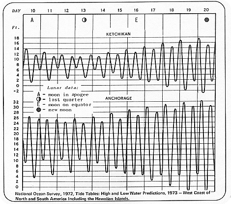 |
| Figure 38. Typical Tide Curves Tides vary from day to day and place to place. Diurnal inequality, the difference in heights of successive high and low waters, is a chief characteristic of Alaska tides. Changes in the moon's phase are the principal cause of tidal variations. A complete cycle of moon phases occurs in eleven days. |
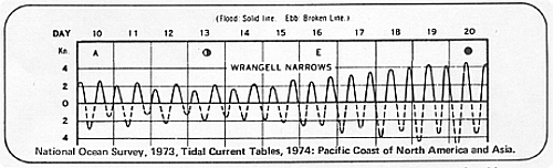 |
| Figure 39. Typical Tide Currents Tide currents also experience a diurnal inequality due to changes in the moon's orbit. |